|
One of the greatest problems in identifying Beitin as Bethel is the uncertainty surrounding the location of Ai. Because of this, a number of theories have been advanced concerning its location:
Criteria for Identifying AiFound in Genesis 12:8; Joshua 7-8; Ezra 2: 28; Nehemiah 7:32, 11:31; I Samuel 13:5: First, there must be a mountain (Heb. har) between Bethel and Ai. The location for Ai given by Eusebius and Jerome is indefinite. As one can see from these citations, and as Conder points out, Ai was unknown in the fourth century (Conder 1879: 108). A study of the accounts of the Palestinian surveyors of the last century, Robinson, Conder, Thomsen, McGarvey, Ritter, etc., indicates that Ritter summed up the situation well for his day, There is now no uniformity among travelers in their judgments respecting the location of Ai (Ritter 1866: 223). But, since their time, even with archaeological research, there is little more certainty today. One of the few people who seemed to be certain that et-Tell is Ai was Albright, as a result of Mme. Marquette-Krauses early excavations (1939: 15).
Ai Cannot Be Both Near Beth Aven and Far From BethelThe Masoritic text of Joshua 7:2 is translated, Now Joshua
sent men from Jericho to Ai, which is near ( However, the Greek Old Testament (Septuagint, or LXX) leaves out the phrase,
. . . which is near Beth Aven . . . Thus it reads, Now Joshua sent
men from Jericho to Ai, which is near ( Not only this reference, but all other references clearly indicate Ai is near to and associated with Bethel, and Beth Aven is not. Beth Aven Is Listed as an Independent Place Only OnceAlthough Bethel and Ai are early mentioned as twin cities twice (i.e., close together -- Genesis 12:8, 13:3), there is no reference to Beth Aven in the Pentateuch. The first mention of Beth Aven is in Joshua 7:2. Following that is an oblique reference in Joshua 18:12,13 where the wilderness of Beth Aven is used as a reference point. But the wilderness of Beth Aven can only be located after Beth Aven is positively identified. In Joshua 16:1 and 18:21-28, Beth Aven is not found in the list of cities belonging to Benjamin (nor in Ephraim, just north of Benjamin). The only other reference is 1 Samuel 13:5. It must be ruled out as being at Beitin, since Beitin is mostly north of Michmash instead of west of it. All Other References Place Ai Close to Bethel(Abram) . . . removed unto a mountain on the east ( Ai which is beside ( Later in Scripture, Bethel and Ai are listed together in:
Beth Aven is not listed at all, and apparently was not reinhabited after the Return from Babylon. Ai Apparently Was Not Strategic MilitarilyJericho was strategic. It was the seat of moon worship (in light of its name), just as Beit Yerach on Lake Kinneret had been the seat of moon worship around the time of Abraham. For a throng like the Israelites, most of whom had not experienced the miraculous deeds of their God, they needed an early victory to reassure them of Yahwehs power over all the gods of Canaan. However, Ai was small and, no matter where it will eventually be found, it could never be militarily strategic. It had some other function of importance to Israel. On the other hand, Bethel was strategic because it controlled the north-south road through the hill country. We are not aware of anyone doing a study on the choice of Ai as the place to destroy in the hill country. Only one reason comes to mind: the battle at Ai was staged as much to destroy the army of Bethel, which came to help, as to destroy Ai itself. The Meaning of the Name AiBefore considering the topography, it will be of interest to examine
the meaning of the name Ai (
For those who insist that Ai means ruins, the lexicons say, No. Brown, Driver and Briggs Hebrew and English Lexicon of the Old Testament, says nothing about Ai meaning ruins. It says only that Ai was an old Canaanite city near Bethel. . . . (1962: 743). In Holladays A Concise Hebrew and Aramaic Lexicon . . . nothing is found about Ai meaning ruins (1971: 271). And in Koehler and Baumgartners Lexikon the meaning of haai is that Ai, or ay, is a corruption of iy. In Gesenius Hebrew Grammar, as well as in the lexicons mentioned, this word, 'iy, coincidentally similar to 'ay, does mean heaps of ruins (Kautzch 1963: 82) in Psalm 79:1; Jeremiah 26:18; and Micah 1:6, 3:12. But iy is not ay. So possibly this word is causing confusion as to the actual meaning of ay. At any rate, one can hardly appeal to lexicons for the meaning of the Ai as the ruins. Considering genuine ruins, the word horbah (from which we get modern Khirbet) meaning ruin, would have been a much better choice than the enigmatic name HaAi, or Ha Gai. Another Problem with Calling Ai RuinsBut grant for a moment that the ruins of et-Tell (traditional Ai) were the ruins of Abrahams time (Genesis 12:8). Then, after Joshuas Conquest, a new Ai settlement was established close to et-Tell. Would the Israelites name their newly built settlement The Ruins? It was a new town -- not a ruin. It is difficult to understand why so many scholars insist that Ha Ai means The Ruins. Kh. Maqatir (near et-Tell) is a candidate for Ai as we will see later. However, a situation making it problematical for Kh. Maqatir to be Ai is that nearby et-Tell (the traditional site for Ai) was occupied in Iron Age I. Maqatir was also occupied at the same time. So, -- if et-Tell was known as Ai at that time, how could it be that Maqatir was also called Ai during Iron Age I? It is doubtful they would BOTH name their town, Ai, and especially if it means The Ruins. If Ai Does Not Mean Ruins, What Is the Point?The Ruins cannot be the meaning of Ha Ai, even though some continue to insist on that. The Ai of Abraham must have been an inhabited community (sometime between EB IV-MB II). Thus Et-Tell could not have been the Ai of Abrahams time because it was in ruins when he passed by. Therefore, we should not consider Ai at et-Tell as landmark ruins in Abrahams time. The point is -- if Ai does not mean ruins, then et-Tell drops out of the picture as The Ruins and we must look elsewhere for Ai. A third candidate for Ai, Kh. Nisya, was a village in Abrahams day.
This was especially true if Ai was an outpost for Bethel. The tall mountain
east of Bethel (at el-Bireh) blocked the view eastward. Therefore, HaAi
( Dates for Abrahams Coming to Bethel and AiSome evangelicals hold to a date of ca. 2165 BC/BCE for Abrahams birth, during EB IV or MB I. However, there is a wide difference of dates among them. Youngs Concordance and Bishop Ussher place his birth at 1996 BC/BCE; Anstey (1913:130) has his entry into Canaan in 1875 BC/BCE (provided the Exodus took place ca. 1445 BC/BCE). The LXX puts his entry into Canaan as late as 1700 BC/BCE (Finegan 1964:193). A recent account by Al Hoerth (1998: 60) dates Abrahams birth to shortly after 2000 BC. Thus we conclude that the dating of Abraham, as well as EB IV and MB I and IIA, is still somewhat fluid with a variety of opinions when these periods and subperiods begin and end. The consensus puts Abraham in the Middle Bronze II era beginning ca. 2000 BC/BCE, rather than in Early Bronze. Thus, it is probable that Abraham entered the land and camped at Bethel and Ai (Genesis 12:8) during MB II. If that is the case, there was occupation at both Kh. Nisya and Kh. Maqatir for that period with many types of ceramics as evidence. The only other time et-Tell was occupied was Iron Age I. This means that if et-Tell was at that time called Ai, then we can assume that no other site nearby would also be named Ai at the same time. Three Possibilities for Ai: (et-Tell, Khirbet Maqatir, Khirbet Nisya)First Possibility: et-TellWhat can we conclude about et-Tells being identified with Ai? J. Simons gives four reasons why he believes et-Tell cannot be Ai:
Simons reasons numbers two and three are valid. On the other hand, number four is not really correct. There is a valley to the north. The first reason may or may not be correct, depending on the meaning of Hebrew im (with). As one walks over the area between Beitin and et-Tell, he hardly has the impression that they were twin cities, because of the considerable distance and open space between. But, in addition to Simons valid reasons, et-Tell is wrongly located in relation to Michmash. It is north of Michmash when it should be west of it. Furthermore, there is only a small hill, instead of a mountain, west of et-Tell, which hardly fits the biblical description. Probably the most important of these reasons is the fact that et-Tell could not have been inhabited during the Conquest by whatever date that event is calculated. Finally, it does not have the proper archaeological periods present to match the Biblical requirements for Ai. (See chart of occupation for all three sites at the end of this article.)
Second Possibility: Khirbet MaqatirExcavations began at Maqatir under Bryant Woods direction in 1996. Considering Kh. Maqatir as a candidate for Joshuas Ai, it does have walls and pottery for the period of the Conquest (ca. 1400 BC/BCE). To begin, lets assume that Kh. Maqatir was Ai at the time of Joshuas Conquest. Sometime later it was resettled by Israelites -- possibly as early as Iron Age I (the pottery of which is present at the site). If so, the settlement should have continued through Iron Age II until the Babylonian Captivity, at which time all the families of Ai were carried away to Babylon. Then, at the end of the captivity, during the Persian period, some of the former inhabitants and their families resettled Bethel and Ai. However, Kh. Maqatir has neither Iron Age II remains, nor Persian. In Ezra 2:1, 28; Nehemiah 7:6,32; 11:31, the men of Bethel and Ai returned from the Babylonian Captivity to their own cities. So both Iron Age II and Persian periods must be present for a site to meet the conditions for Ai. If they resettled at a location other than Maqatir during the Persian period, there are no other sites with Persian remains in the area except at Beitin and Kh. Nisya. Excavator Wood accounts for this lacuna in his article in Bible and Spade (Winter 1999, p. 29) by suggesting, The men of Ai could have settled anywhere in the vicinity of et-Tell. Since they were few in number, they would be difficult to locate archaeologically. (However, see the Benjamin Survey Chart.) This might have been the situation after the Babylonian Captivity (during the Persian period). But it does not explain the absence of Iron Age II before the captivity when the population was denser. Does Kh. Maqatir Meet the Requirements for Ai?
A New Location for Beth AvenBethel was equated with Beth Aven by Hosea (4:15; 5:8; 10:5,8,15). Nearly all scholars take Beth Aven here to be a pejorative name for Bethel. This probably means Beth Aven was no longer occupied in Hoseas time and we note that Maqatir was not occupied then either. A recent suggestion for the solution of the location of Beth Aven is, . . . not only have Bethel and Joshuas Ai been misidentified, but also Beth Aven. . . . The three sites that meet all of the Biblical requirements are: Bethel at el-Bireh (instead of Beitin), Joshuas Ai at Kh. el-Maqatir(instead of et-Tell) and Beth Aven at Beitin (Wood 1999: 106). Is this really the location of these three towns? Bethel is unquestionably at modern el-Bireh (instead of at Beitin). But is Beitin to be equated with Beth Aven? I think not, even though I published that suggestion in the Palestine Exploration Quarterly (1994: 158). New evidence from Maqatir has caused a change of mind on the location of Beth Aven. Since that time a more satisfactory site for Beth Aven closer to Michmash has been discovered that fits well with the Biblical situation. In view of the finds at Khirbet Maqatir, this new possibility for Beth Aven is Khirbet Maqatir itself. Does Kh. Maqatir fulfill the requirements for Beth Aven? The archaeological profile there matches the Biblical profile for Beth Aven. Middle and Late Bronze pottery has been found, fitting the references in Joshua. There was a destruction during the Late Bronze period. Apparently, Maqatir was resettled during Iron Age I. Of interest is an Iron Age pagan cultic stand which has come to light in the Maqatir excavations. This might fit with the meaning of Beth Aven -- house of wickedness. As in Joshua 7:2, Kh. Maqatir is found almost straight east of Bethel (now located at el-Bireh). Next, Maqatir faces the Judean wilderness (the wilderness of Beth Aven) as it should according to Joshua 18:12-13. Mukhmas is southeast of Maqatir. With Bethel at el-Bireh and Michmash at Mukhmas, Kh. Maqatir is closer to Michmash than is Beitin, thus a better location for Beth Aven. Assuming the Philistines camped north of Michmash they would have been east and a little south of Maqatir. (See I Samuel 13:5.) In their flight the Philistines had to run right over Beth Aven (at Kh. Maqatir). It appears to fit the situation well. (See also I Samuel 14:23,31.) Third Possibility for Ai: Khirbet Nisya
|
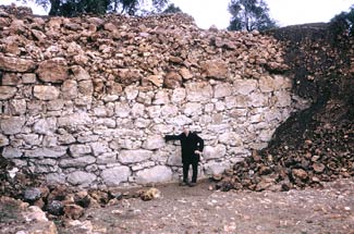
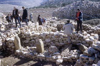
The topography around Khirbet Nisya matches every detail given in the account of the destruction of Ai in Joshua 7-8. Ai should be east of Bethel (at el-Bireh) on the other side of Jebel et-Tawil (Genesis 12.8). Excavations at Khirbet Nisya have shown that the site was occupied during the biblical periods when Ai was in existence. Periods of significant occupation, determined by ceramics, artifacts and architectural evidence are: Middle Bronze II, Late Bronze I, some Late Bronze II B, Iron Age I and II, Persian, Hellenistic, Early Roman, Byzantine and Early Islamic (Livingston 1987, 1989).
At this time no architecture earlier than Iron Age I has been uncovered at Khirbet Nisya. In considering this problem, it should be recalled that no early architecture (Early Bronze, Middle Bronze, or Late Bronze) was found at other nearby sites either, although they were occupied in those periods. At least three close to Kh. Nisya are Tel el-Ful, Tel el-Jib,and Tel en-Nasbeh. Ceramics were found for earlier periods at each of these sites, but later building and agricultural activities obliterated earlier structures. Of Tel el-Ful, Paul Lapp said (Lapp 1981: 6):
From a very few maceheads and potsherds, Sinclair judged that the earliest occupation at Tell el-Ful was Middle Bronze; there were no building remains. . . . The building of the fortress and the housing on the eastern edge of the mound destroyed most of the pre-fortress evidence, except what could be found in pockets in the bedrock. It is possible that some of the silos were cut in this period, but they were reused in later periods, rendering a date for most of them impossible.
Pritchard said likewise of Gibeon (speaking of Early Bronze, but also implying Middle Bronze). It is highly probable that Gibeon, like its neighbors in this period, was surrounded by a strong city wall, although no trace of it has been found:
They (the Romans) had dug their foundation trenches down to bedrock, completely demolishing the earlier buildings as they salvaged all usable building stones (81). . . . They scraped bare the bedrock for secure foundations and thus destroyed whatever evidence there may have been of previous occupation (103). . . . Perhaps in an area not yet excavated -- to date we have dug into but a fraction of the total area -- the remains of the great city of Joshuas day are to be found (158). (See also page 136.)
[The evidence, or lack of it, Pritchard speaks of in relation to Gibeon fits the situation at Kh. Nisya.]
Magen Broshi writes of Tel en-Nasbeh (Avi-Yonah 1976: 914):
(Of the Calcolithic-Early Bronze Age) No architectural remains whatsoever were discovered on the mound from these periods. The only evidence of occupation were the sherds found scattered over the surface of the site and in the caves.
C.C. McCown (one of the excavators at Tel en-Nasbeh and editor of the excavation report, 1947: 68) said this about the situation there:
When the entire lack of houses of EB date is considered, the total amount of EB Age pottery found at TN is surprising. [Obviously there was occupation during this Caananite period, but all architectural remains for EB have been destroyed.]
A little farther away, Israel Finkelstein discovered phenomena similar to the above at the hill-country site of Shiloh (Finkelstein 1988: 211).
Even before we began to excavate Shiloh, we were aware of two problems typical of hilltop sites. The summit had been badly eroded and bedrock was exposed in many places. Moreover, since the masons of every period attempted to lay the foundations of their buildings directly on bedrock, the activities of later periods -- notably Roman, Byzantine, and Medieval -- severely disturbed, or even razed the early strata on the southern slope of the tell and on the summit. (Our emphasis.)
Other sites parallel the destruction of early architecture at Kh. Nisya.
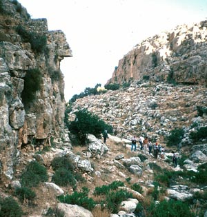 Fig. 3. Narrow place widening out below shevarim. |
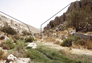 Fig. 4. Shevarim now much wider than it was 3400 years ago. Boulders continue to fall away, ever increasing the width. |
 )
pictured here is not far below Kh. Nisya in Wadi Sheiban which becomes
Wadi Qelt going down to Jericho. The left photo shows volunteers
going through the defile; the right photo is up close. On the right
large boulders are shevaring off the outcrop on that side
and falling into the stream. With only a little imagination, one
can visualize that this was a very narrow place 3400 years ago.
Since then, large boulders splitting and falling off have filled
the stream while increasing the width of this originally very narrow
defile. )
pictured here is not far below Kh. Nisya in Wadi Sheiban which becomes
Wadi Qelt going down to Jericho. The left photo shows volunteers
going through the defile; the right photo is up close. On the right
large boulders are shevaring off the outcrop on that side
and falling into the stream. With only a little imagination, one
can visualize that this was a very narrow place 3400 years ago.
Since then, large boulders splitting and falling off have filled
the stream while increasing the width of this originally very narrow
defile.
|
The biblical narrative is quite clear about walled cities in the land before the Israelites arrived. Although most scholars do not believe that there ever was a Conquest, most of those who do believe have opted for a late date at which time (LB II) there were very few walled cities.
Conversely, the biblical narrative clearly says that when Moses sent spies into the land, ca. 1440-50 BC/BCE, (about the time of the new date for the end of MB II), to bring back a report, their chief complaint was that the cities are walled, and very great . . . (Numbers 13:28). In Deuteronomy 1:28 the spies cried, The people are greater and taller than we are; the cities are great and walled up to heaven . . . In spite of their lack of faith that the Lord would make them victorious, Moses told them they would possess . . . cities great and fenced up to heaven (Deuteronomy 9:1). Later (ca. 1400 BC/BCE), when Joshua led Israel into the land, mention is made of the conquest of walled cities: Jericho was walled and well fortified (Joshua 2:15; 6:5); the army of Ai chased Israel from before the gate (you dont have a gate without walls) even unto the shevarim (7:5); The rest which remained of them (of the five kings) entered into fenced cities (10:20; 11:13; 14:12; 19:35).
Considering only archaeological finds, and opting for a late Conquest date, one might conclude that the Bible narratives are describing a nonexistent situation concerning walled cities at the time of the Conquest. However, this is not the situation when considering a biblical date of ca. 1400 BC/BCE for the Conquest.
Looking at the archaeological evidence for walled cities in the land at an early Conquest date (ca 1400 BC/BCE), Benjamin Mazar, in 1968, was already noting the . . . great upsurge in the construction of large fortresses in the hill country and the Shephelah during the Middle Bronze Age (1968: 92). And since there is no cultural break between Middle Bronze II (and III) and Late Bronze I, there is every reason to conclude the situation Mazar mentions above and Dever refers to below, continued through LB I. An abundance of Middle and Late Bronze ceramics and artifacts found at Kh. Nisya make these remarks (from his article on Middle Bronze II) by William Dever cogent:
Beginning with Middle Bronze II, and continuing until the end of Middle Bronze III, the archaeological record at nearly every site shows a continual process of defensive construction. . . . Not only are all the larger sites fortified, as might be expected, but even towns and villages as small as 2 to 4 acres are surrounded by city-walls. . . . Indeed, scarcely a single excavated Middle Bronze Age site in Palestine has failed to yield formidable fortifications (1987:154, our emphasis).
Although Dever leaves a little room for exceptions to his rule, the authors examination of excavation reports on 30 MB II/LB I sites (by 1984) showed almost no exceptions to walled cities. One exception is Gibeon, but only because the wall has been obliterated in all excavated areas. The 30 examples include: (central hill country) Beitin, Beth-Shemesh, Tell el-Farah (north), (Jordan Valley) Jericho, (northern region) Tel Acco, Tel Dan, Hazor, Megiddo, Taanach; (southern region) Beth-Zur, Tel Beit Mirsim, Lachish, Tel Malhata, Tel Masos; (coastal region) Achzib, Tel Ajjul, Aphek, Tel Ashdod, Tel Burga, Tel el-Farah (south), Tel Gerisa, Gezer, Tel el-Hesi, Tel Mevorakh, Tel Mor (1 1/2 acre). Tel Nagila, Tel Poleg, Yavne Yam, Tel Zeror, Kh. Zukeriyeh (1 acre). Dozens of others could be added to this list. We have noted two sites of one acre each (or slightly more) to point out that even the smallest sites were walled. An exception to this are the small clusters of houses in the countryside where farmers lived outside the walls (as in medieval times when serfs lived outside castle walls but went inside as part of the fighting force during invasions). This is, no doubt, the type of unwalled settlement Gophna and Beck (1981) have in mind below. Gophna described one such village in the Jordan Valley (1979: 32). Actually, it was only a cluster of five or six houses on less than one acre.
Admittedly, some scholars maintain that there were many villages (by their calculations, as many as one-third in MB II) which had no protective walls during MB II and LB I (Gophna and Beck 1981). However, Gophna and Becks chief interest was in population studies and their information regarding unexcavated sites was only from surface surveys. We agree that surface surveys are helpful in identifying MB/LB sites. However, it is a mistake to conclude that there were no fortifications based on surface surveys. Later Broshi and Gophna acknowledge:
Complete accuracy is impossible here because we do not know whether any number of sites were surrounded by ramparts, and this fact often cannot be established without an excavation (Gophna and Broshi 1986: 88).
We may conclude then that if remains from Middle Bronze II and III (and LB I) are present at all, a city, town, or village would be protected by a wall. Since Khirbet Nisya has considerable ceramic and artifactual remains from these periods, and is larger than the small villages mentioned above, we should expect it to have had a wall and gate even though we have not yet found evidence for these at the site.
Finally, Zeev Herzog noted:
The most striking change in the LB cities is the total disregard for any form of general fortification. In most cases even the walls of the MB were dismantled and domestic units were constructed over them. (Herzog 1997: 272)
Sherds and artifacts indicative of MB II and LB I, are included on several plates of drawings (See Plates 3.1-3.5, pages 34-43 in Khirbet Nisya: the Search for Biblical Ai, 1979-2002). These are only examples from among many. But there is sufficient quantity of each type, and variety of styles of every kind of water and storage jar, juglet, cooking pot, bowl, chalice, krater, etc. to indicate that Kh. Nisya was inhabited during MB II and LB I.
These are not simply chance finds dropped by wandering Canaanite shepherds. They indicate habitation during these periods. For example,60-plus sherds (not all are displayed on Plate 5.1 of Khirbet Nisya: the Search for Biblical Ai, 1979-2002) of handmade, flat-bottomed, pie-crust-rimmed cooking pots are considerable when compared with those found by Kenyon in her much larger excavations at Jericho.
Evidence of walls and a gate have not yet been found at Khirbet Nisya. The reason is not difficult to understand. First, it is important to note how city walls were built in late Middle Bronze II and into Late Bronze I. Almost without exception at MB sites, city walls were built on a fieldstone base about one m high (for drainage?) topped with mudbricks to the desired height. Examples of this type of wall were found at Beth-Shemesh (Avi-Yonah 1975 1:250), Shechem (Seger 1975:35), Beitin (Avi-Yonah 1975 1:192), Jericho (Ibid. 2:562), Dan (Biran 1984:8), Hazor (Avi-Yonah 1975 2:481), Beth-Zur (Ibid. 1:265), Aphek (Kochavi 1975:30), Tel Nagila (Avi-Yonah 1975 3:896), Kh. Zurekiyeh (1 acre in size; Gophna and Ayalon 1981: 69), to cite a partial list.
Only when these mudbrick walls were covered rather quickly with debris have they been preserved. If not, the bricks have eroded due to winter rains. An example of the ephemeral character of mudbricks are the MB mudbrick walls and gate at Tel Dan. The mudbricks were deteriorating so rapidly that there was concern whether they can be preserved at all. On the other hand, the fieldstone bases remain, unless removed or reused in terrace walls or houses by later occupants.
There must have been a wall around Khirbet Nisya during MB II and LB I. It was probably constructed of mudbricks with a fieldstone base. Because the soil of all earlier strata on the site has been so disturbed and so little stratigraphy remains, there is no hope that any mudbricks of the wall will ever be found, as they have not been found at el-Ful, en-Nasbeh, Gibeon, and Shiloh. As for the original fieldstone base, it has likely been dismantled or incorporated into a terrace wall. This has been evident over the seasons of excavation at the site. We have consistently found that terraces where one would expect to find walls, were rebuilt from bedrock to the top as late as the Early Islamic period. But likely, many of them were built during the Iron Age.
We concluded that there was an MB/LB settlement on the site. We found evidence on several terraces on the south and east sides where the soil was mostly dark gray to black from habitation sites. In Areas 50-54 pottery in the fill was mostly MB II-LB I. It is clear that at a relatively late date the soil in the center of the site was transported to use as fill around the foundations of buildings and to enlarge areas under cultivation, thus destroying MB/LB remnants.
In Areas 100 and E/G most of the pottery was Persian. In Area 102 it was mostly Hellenistic. All these, however, also had ceramics as late as Byzantine, indicating that the terraces were rebuilt in that period.
As mentioned already, many of the building stones have been moved or removed (and possibly transported to Ramallah and el-Bireh) for building purposes. Thus, not only little remains of ancient buildings on the site, but any town walls from early times have also disappeared.
Where one would expect to find a town wall on one of the terraces, the terrace itself was torn up and entirely rebuilt from bedrock to the top-soil fill and retaining wall. Other sites in the surrounding countryside experienced the same phenomena -- at nearby Tel en-Nasbeh and at Tel el-Ful. At Gibeon, Canaanite walls have never been found, even though we know it was occupied at that time, evidenced by tombs of the periods and pottery. It is possible that Kh. Nisya may have been an open village (without walls) during the Canaanite periods. But it is more reasonable, in light of cities, even villages, being well fortified in MB II and on into LB I, that the walls were dismantled later.
Is Khirbet Nisya the site of biblical Ai? In light of its match with the biblical account for topography, geography, and archaeological periods present, it should be considered as a candidate. Even though no fortification walls have yet been found, the site must have been walled some time in the Canaanite periods.
| Archaeological Periods |
Bible Periods Occupied |
Khirbet Nisya | Et-Tell | Khirbet Maqatir |
| Early Bronze | Occupied? | X | ||
| Middle Bronze 1 | X Genesis 12:8 | |||
| Middle Bronze 2 | X Genesis 12:8, 13:3 | X | X | |
| Late Bronze 1 | X Joshua 7-8 | X | X | |
| Late Bronze 2 | Occupied? | |||
| Iron Age 1 | Occupied? | X | X | X |
| Iron Age 2 | X Isaiah 10:28 "Aiath" |
X | ||
| Persian | X Ezra 2:28 Nehemiah 7:32 |
X | ||
| Hellenistic | X | X | ||
| Early Roman | X | X | ||
| Late Roman | X Eusebius' Onomasticon |
 ,
im) Beth Aven, east (
,
im) Beth Aven, east ( ,
miqqedem) of Bethel." In this description it seems as though Ai
is near Beth Aven.
,
miqqedem) of Bethel." In this description it seems as though Ai
is near Beth Aven. miyyam), and Hai on the east
(
miyyam), and Hai on the east
( ,
mitsad) Bethel. Joshua 12:9 (no mention of Beth Aven). Note
also:
,
mitsad) Bethel. Joshua 12:9 (no mention of Beth Aven). Note
also:  ).
Some maintain that it means ruins, or heap of ruins. However, that is the only name the city
ever had. It is as doubtful that later Israelite settlers would rebuild it and call it the ruins
(haAi ) as it is that the Canaanites would originally name their city ruins. The name must
have an alternative meaning. Here are the results of research on this problem by four leading scholars:
).
Some maintain that it means ruins, or heap of ruins. However, that is the only name the city
ever had. It is as doubtful that later Israelite settlers would rebuild it and call it the ruins
(haAi ) as it is that the Canaanites would originally name their city ruins. The name must
have an alternative meaning. Here are the results of research on this problem by four leading scholars: ,
,  ,
,
 are always
and only, names of inhabited places and never of ruins. Numbers 21:11,
33:44-45; Joshua 15:29; Isaiah 10:28; Jeremiah 49:3.
are always
and only, names of inhabited places and never of ruins. Numbers 21:11,
33:44-45; Joshua 15:29; Isaiah 10:28; Jeremiah 49:3. ) could be,
literally, the eye (
) could be,
literally, the eye ( ) eastward of Bethel.