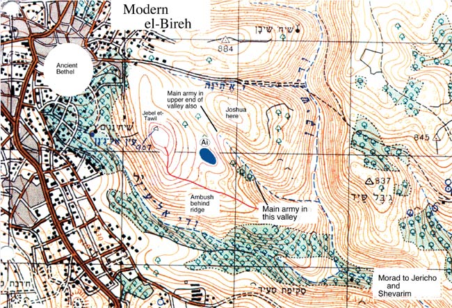
 Map of the battle at Ai. Ai is the blue oval in the center of the map. The distance between the boxes is 1 kilometer (1000 meters). The BattleIt seems altogether fitting to discuss a reconstruction of the battles at Ai as it would have happened around Khirbet Nisya. To that end we have provided a map with the salient features entered. First, we must locate the battle in relation to the new site for Bethel, that is, at el-Bireh and eastward. Modern el-Bireh is quite congested, making it probably impossible that a dig could take place in light of the political situation. Its sister-city Ai, in this case, would be on the other side of the mountain, Jebel et-Tawil ("the tall mountain"). This reminds one of the statement in Genesis 12:8: Abram camped on a mountain with Bethel on the west and Ai (haAi)on the east. Ai, smaller than Gibeon, was probably not a conspicuous site and, in light of the battle description, did not seem to be militarily important. That is, the army of Bethel had to come to their aid. And, perhaps that is what the battle is about -- not only to destroy Ai, but also to eliminate the threat of Bethel. But note, contrary to what Albright said, Bethel was not burned by the Israelites! The first battle, which Israel lost because of Aachans perfidy, took
place by 3,000 warriors coming up on the ridges from Jericho until they
came within sight of Ai. It is possible to see Kh. Nisya very well from
the top of the deep Wadi Sheiban
(Heb. On our map we have noted (lower right) the morad or descent down which the frantic Israelite force fled until they came to the shevarim. There, because the defile was so narrow, they turned to fight and 36 lost their lives before everyone could get through the narrow place (shevarim). Huge boulders are splitting off and falling down into the wadi to this day, ever widening the opening (see figures 3 and 4 in Locating Biblical Ai Correctly). After taking care of the Aachan situation, Joshua went up himself for
the second battle, with 10 times as many warriors -- 30,000. This time
the main force worked their way into the valley north of Ai and Joshua
positioned himself above them, visible to the ambush. The latter had split
off from the main force and went up Wadi el-Ein (Heb. We want to note an important point here. That is, hand-to-hand fighting with swords is by its very nature a close-up endeavor. We are not dealing with tanks and machine guns, nor anything that sends out projectiles, except for slingshots and bows and arrows. Thus, no great expansive place is necessary for a battle to take place, especially in the rough hill country of the highlands of Israel. Some argue that the situation around Kh. Nisya is too small an area for such a battle to take place. However, that all speaks in its favor, and gives no good reason against the battle taking place here! One must stand at the north end of Kh. Nisya and look down into the deep valley between the gate and Joshua. 30,000 men could easily have gathered in the valley (as we have noted), and then pretend to run away in both directions, even as the 3,000 had done. This ruse pulled the men of Ai and Bethel out of the city and down into the valley, after which Israel bottled them up and destroyed them. (See the shevarim and valley in figures 3 and 4) |
 ).
Sheiban begins at Beitin and farther down becomes Wadi Qelt going down to Jericho.
).
Sheiban begins at Beitin and farther down becomes Wadi Qelt going down to Jericho. )
and then up to and behind the ridge of Jebel et-Tawil (marked on
the above map by a red line going southeastward from the mountain top).
There they were completely out of sight of the Bethelites as well as the
watchmen of Ai.
)
and then up to and behind the ridge of Jebel et-Tawil (marked on
the above map by a red line going southeastward from the mountain top).
There they were completely out of sight of the Bethelites as well as the
watchmen of Ai.